31st Oct - 1st Nov 2024
 |
| Fogo Island. Chā das Caldeiras (Cauldron) with the Pico do Fogo volcano (9,281ft AMSL) |
I'm no 'volcanologist' but the trip up to and into the Chã das Caldeiras crater was most interesting. The crater is about 9km in diameter and is designated as a National Park.
My driver, Claudio, picked me up at the hotel at 10.00am as promised and off we set towards the rim of the crater. We communicated in a combination of broken English and my schoolboy French (many Cape Verdians speak a bit of French due to many French tourists I believe). The journey via little villages such as Patim and Salto took about an hour (see map previous blog) The final climb was up a steep ziz-zag road (marked on the map).
Left: Looking back down towards São Felipe to the west.
There have been many major eruptions from within this crater (not all from the main 'Pico' but other 'spouts' within) over the centuries and the volcanic area is still active. The most recent and destructive eruptions were in 1951, 1965 and a 'biggy' in 2014.
Arriving towards the southern edge of the rim, there are large areas of black lava which had streamed down south (right) following the 1951 eruption. Much of the sandy type lava is scooped up and used to make building blocks.
Left: Over the rim and a narrow cobbled (and decently maintained) road takes you around the west and north the inside the crater. A popular route for tourists.
Right: To be greeted by the sight of an enormous lava field with the Pico do Fogo in the background. Some of the lava is sandy/gravelly and some enormous black slabs or boulders.
Left: The towering cliffs which surround the crater. The cobbled road follows along inside.
What amazes me is that the inside of the crater has been inhabited, and still is, with little houses and villages. The lava 'soil' is very fertile and grapes and other fruit are grown extensively. The wine produced in the vineyards here is considered very good.
Right. Grape vines, or maybe some other fruit, growing in the shadow of the volcano.
There were/are two main villages on the north-western side; Portela and Bangaeira. Both were completely wiped out by the 2014 eruption with many fatalities.
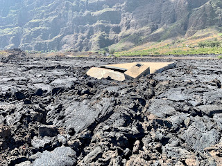
Left: A bit of the previous Portela protruding through the lava.
Right: The triangular brickwork is the top of the previous Catholic church in Portela. Most of the original village is 20 metres under the lava.
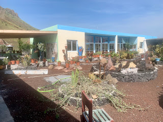
Left: Nothing daunted, a new Portela has been/is being built, and in the process of expanding.
Right. New houses and little shacks have sprung up amidst this desolate landscape. They are a hardy, and optimistic, folk!
Left: More little huts abound. I think they are used by the people who tend the vines and fruit plantations.
Right: Plus some more elegant accommodation.
Left: Most of the new buildings are constructed using lava blocks and bricks.
Right: A poor blurry photo but shows the initial track used by those fit, energetic and adventurous tourists who take a guided tour up the top of Pico Fogo. There is a vertiginous crater at the top and visitors are hooked onto safety lines to look down into it. This 'walk/climb' takes about 4 hours to go up and 3 to come down depending on ones fitness and involves wading through knee high lava dust at times. I resisted the challenge!
Left: The village of Bangaeira which is north of and below Portela. This too was wiped out by the 2014 eruption but is rising again from the ashes. Good luck to them!
Right: Portela is a popular venue for tourists. I was taken to this bar to sample some of the local wine. It tasted fine, but I am no connoisseur. I met a local here who is one of the 'Pico Volcano' guides. He spoke good English. He told me at busy periods he would escort climbs up the mountain every day for a week! He must be fit!
Left: I couldn't help notice this sign on the wall of the outside bar. As if smoking in this environment poses a greater threat! As it happens, as compared to most Western 'elf 'n safety' regulations, the locals pay absolutely no attention. I noticed that no seat-belts are ever worn in cars. Their 'risk analysis' is somewhat more 'flexible' than ours.
Right: I had a very good lunch in this smart hotel in Portela. It is owned by a man, originally from Uzbekistan, and his Cape Verdian wife. He has a most interesting history and has lived in Fogo for 17 years.
I did pose the question "is it not a bit risky?". He shrugged his shoulders and said he hoped there would not be another eruption for at least 50 years. In the meanwhile he makes a good living from the tourists who stay here. It is not cheap.
Left: It even has a Pool table (nota bene the Hungerford GPS).
Right: Around the periphery of this hotel are several rather 'chi-chi' chalets. They looked most comfortable with sun-loungers on top. As said, they cater for a substantial number of tourists. Having said that, while I was here, I saw few.
That will do from the 'Cauldron'. My driver, Claudio, was very charming and educational and even good at driving. We got back to Sãu Felipe at about 4.00pm.
Finished this in a rush, so may need to correct many typos (OMPITA take note).
Off back to Santiago tomorrow so maybe more riveting news from there.


Have a great trip - Pam
ReplyDelete